|
| at: |
Sumter National Forest - Long Cane District |
Data from USFS GIS
 show on map
 animate
Trail users:


Elevation Profile
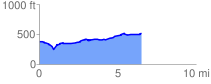
 6.583588 mi
 375.13 ft
 236.69 ft
 138.43 ft
 1.08 %
GPX Downloads: Track Route
![]()
|
| at: |
Sumter National Forest - Long Cane District |
show on map
animate
6.583588 mi
375.13 ft
236.69 ft
138.43 ft
1.08 %