| at: |
Sumter National Forest - Long Cane District |
Data from USFS GIS
 show on map
 animate
Trail users:


Elevation Profile
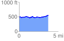
 3.800274 mi
 247.83 ft
 207.36 ft
 40.48 ft
 1.24 %
GPX Downloads: Track Route
![]()
| at: |
Sumter National Forest - Long Cane District |
show on map
animate
3.800274 mi
247.83 ft
207.36 ft
40.48 ft
1.24 %