|
| at: |
Chestatee WMA |
Data from David Muse
 show on map
 animate
Trail users:


Elevation Profile
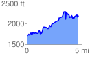
 4.706357 mi
 1644.13 ft
 1190.18 ft
 453.95 ft
 6.62 %
GPX Downloads: Track Route
![]()
|
| at: |
Chestatee WMA |
show on map
animate
4.706357 mi
1644.13 ft
1190.18 ft
453.95 ft
6.62 %