| at: |
Sumter National Forest - Long Cane District |
Data from USFS GIS
 show on map
 animate
Trail users:


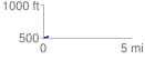
Elevation Profile
 0.290610 mi
 35.38 ft
 5.17 ft
 30.21 ft
 2.31 %
GPX Downloads: Track Route
![]()
| at: |
Sumter National Forest - Long Cane District |
show on map
animate
0.290610 mi
35.38 ft
5.17 ft
30.21 ft
2.31 %