|
| at: |
Sumter National Forest - Long Cane District |
Data from USFS GIS
 show on map
 animate
Trail users:


Elevation Profile
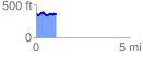
 1.063767 mi
 129.32 ft
 138.55 ft
 -9.22 ft
 2.47 %
GPX Downloads: Track Route
![]()
|
| at: |
Sumter National Forest - Long Cane District |
show on map
animate
1.063767 mi
129.32 ft
138.55 ft
-9.22 ft
2.47 %