| at: |
Sumter National Forest - Long Cane District |
Data from USFS GIS
 show on map
 animate
Trail users:


Elevation Profile
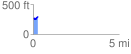
 0.295709 mi
 45.92 ft
 20.70 ft
 25.23 ft
 2.94 %
GPX Downloads: Track Route
![]()
| at: |
Sumter National Forest - Long Cane District |
show on map
animate
0.295709 mi
45.92 ft
20.70 ft
25.23 ft
2.94 %