|
| at: |
Sumter National Forest - Long Cane District |
Data from USFS GIS
 show on map
 animate
Trail users:


Elevation Profile
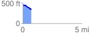
 0.708942 mi
 19.35 ft
 123.11 ft
 -103.76 ft
 3.29 %
GPX Downloads: Track Route
![]()
|
| at: |
Sumter National Forest - Long Cane District |
show on map
animate
0.708942 mi
19.35 ft
123.11 ft
-103.76 ft
3.29 %