| at: |
Sumter National Forest - Long Cane District |
Data from USFS GIS
 show on map
 animate
Trail users:


Elevation Profile
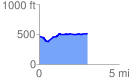
 3.025799 mi
 189.05 ft
 146.88 ft
 42.17 ft
 1.18 %
GPX Downloads: Track Route
![]()
| at: |
Sumter National Forest - Long Cane District |
show on map
animate
3.025799 mi
189.05 ft
146.88 ft
42.17 ft
1.18 %