|
| at: |
Sumter National Forest - Long Cane District |
Data from USFS GIS
 show on map
 animate
Trail users:


Elevation Profile
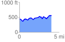
 4.015510 mi
 490.33 ft
 382.16 ft
 108.17 ft
 2.31 %
GPX Downloads: Track Route
![]()
|
| at: |
Sumter National Forest - Long Cane District |
show on map
animate
4.015510 mi
490.33 ft
382.16 ft
108.17 ft
2.31 %