| at: |
Sumter National Forest - Long Cane District |
Data from USFS GIS
 show on map
 animate
Trail users:


Elevation Profile
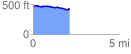
 2.119369 mi
 50.63 ft
 93.78 ft
 -43.15 ft
 0.84 %
GPX Downloads: Track Route
![]()
| at: |
Sumter National Forest - Long Cane District |
show on map
animate
2.119369 mi
50.63 ft
93.78 ft
-43.15 ft
0.84 %