| at: |
Sumter National Forest - Long Cane District |
Data from USFS GIS
 show on map
 animate
Trail users:


Elevation Profile
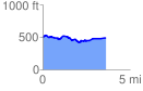
 3.634159 mi
 200.08 ft
 198.78 ft
 1.29 ft
 1.04 %
GPX Downloads: Track Route
![]()
| at: |
Sumter National Forest - Long Cane District |
show on map
animate
3.634159 mi
200.08 ft
198.78 ft
1.29 ft
1.04 %