| at: |
Sumter National Forest - Long Cane District |
Data from USFS GIS
 show on map
 animate
Trail users:


Elevation Profile
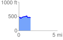
 1.514162 mi
 109.80 ft
 104.02 ft
 5.79 ft
 1.37 %
GPX Downloads: Track Route
![]()
| at: |
Sumter National Forest - Long Cane District |
show on map
animate
1.514162 mi
109.80 ft
104.02 ft
5.79 ft
1.37 %