| at: |
Sumter National Forest - Long Cane District |
Data from USFS GIS
 show on map
 animate
Trail users:


Elevation Profile
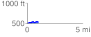
 1.033927 mi
 64.14 ft
 29.66 ft
 34.48 ft
 1.17 %
GPX Downloads: Track Route
![]()
| at: |
Sumter National Forest - Long Cane District |
show on map
animate
1.033927 mi
64.14 ft
29.66 ft
34.48 ft
1.17 %