|
| at: |
Sumter National Forest - Long Cane District |
Data from USFS GIS
 show on map
 animate
Trail users:


Elevation Profile
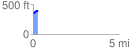
 0.292669 mi
 43.55 ft
 12.13 ft
 31.42 ft
 2.82 %
GPX Downloads: Track Route
![]()
|
| at: |
Sumter National Forest - Long Cane District |
show on map
animate
0.292669 mi
43.55 ft
12.13 ft
31.42 ft
2.82 %