|
| at: |
Sumter National Forest - Long Cane District |
Data from USFS GIS
 show on map
 animate
Trail users:


Elevation Profile
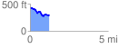
 1.219093 mi
 80.64 ft
 223.68 ft
 -143.04 ft
 3.47 %
GPX Downloads: Track Route
![]()
|
| at: |
Sumter National Forest - Long Cane District |
show on map
animate
1.219093 mi
80.64 ft
223.68 ft
-143.04 ft
3.47 %