|
| at: |
Forks Area Trail System Sumter National Forest - Long Cane District |
Data from USFS GIS
 show on map
 animate
Trail users:


Elevation Profile
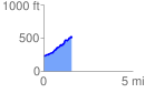
 1.571577 mi
 373.20 ft
 84.08 ft
 289.12 ft
 4.50 %
GPX Downloads: Track Route