| at: |
Sumter National Forest - Long Cane District |
Data from USFS GIS
 show on map
 animate
Trail users:


Elevation Profile
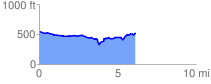
 6.254251 mi
 389.47 ft
 431.07 ft
 -41.59 ft
 1.31 %
GPX Downloads: Track Route
![]()
| at: |
Sumter National Forest - Long Cane District |
show on map
animate
6.254251 mi
389.47 ft
431.07 ft
-41.59 ft
1.31 %