|
| at: |
Sumter National Forest - Long Cane District |
Data from USFS GIS
 show on map
 animate
Trail users:


Elevation Profile
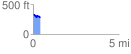
 0.420054 mi
 22.04 ft
 78.72 ft
 -56.67 ft
 3.55 %
GPX Downloads: Track Route
![]()
|
| at: |
Sumter National Forest - Long Cane District |
show on map
animate
0.420054 mi
22.04 ft
78.72 ft
-56.67 ft
3.55 %