|
| at: |
Sumter National Forest - Long Cane District |
Data from USFS GIS
 show on map
 animate
Trail users:


Elevation Profile
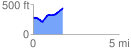
 1.743516 mi
 248.29 ft
 113.92 ft
 134.37 ft
 2.70 %
GPX Downloads: Track Route
![]()
|
| at: |
Sumter National Forest - Long Cane District |
show on map
animate
1.743516 mi
248.29 ft
113.92 ft
134.37 ft
2.70 %