| at: |
Sumter National Forest - Long Cane District |
Data from USFS GIS
 show on map
 animate
Trail users:


Elevation Profile
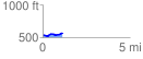
 1.136850 mi
 76.14 ft
 36.82 ft
 39.32 ft
 1.27 %
GPX Downloads: Track Route
![]()
| at: |
Sumter National Forest - Long Cane District |
show on map
animate
1.136850 mi
76.14 ft
36.82 ft
39.32 ft
1.27 %