|
| at: |
Sumter National Forest - Long Cane District |
Data from USFS GIS
 show on map
 animate
Trail users:


Elevation Profile
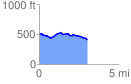
 3.010961 mi
 120.94 ft
 212.78 ft
 -91.84 ft
 1.34 %
GPX Downloads: Track Route
![]()
|
| at: |
Sumter National Forest - Long Cane District |
show on map
animate
3.010961 mi
120.94 ft
212.78 ft
-91.84 ft
1.34 %