|
| at: |
Sumter National Forest - Long Cane District |
Data from USFS GIS
 show on map
 animate
Trail users:


Elevation Profile
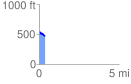
 0.386835 mi
 4.30 ft
 90.33 ft
 -86.03 ft
 4.42 %
GPX Downloads: Track Route
![]()
|
| at: |
Sumter National Forest - Long Cane District |
show on map
animate
0.386835 mi
4.30 ft
90.33 ft
-86.03 ft
4.42 %