|
| at: |
Sumter National Forest - Long Cane District |
Data from USFS GIS
 show on map
 animate
Trail users:


Elevation Profile
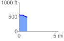
 1.026712 mi
 8.65 ft
 97.13 ft
 -88.47 ft
 1.79 %
GPX Downloads: Track Route
![]()
|
| at: |
Sumter National Forest - Long Cane District |
show on map
animate
1.026712 mi
8.65 ft
97.13 ft
-88.47 ft
1.79 %