|
| at: |
Sumter National Forest - Long Cane District Lick Fork Lake Recreation Area |
Data from USFS GIS
 show on map
 animate
Trail users:


Elevation Profile
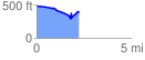
 2.235860 mi
 262.83 ft
 343.34 ft
 -80.51 ft
 2.91 %
GPX Downloads: Track Route