|
| at: |
Sumter National Forest - Long Cane District |
Data from USFS GIS
 show on map
 animate
Trail users:


Elevation Profile
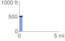
 0.381314 mi
 63.70 ft
 38.38 ft
 25.32 ft
 3.16 %
GPX Downloads: Track Route
![]()
|
| at: |
Sumter National Forest - Long Cane District |
show on map
animate
0.381314 mi
63.70 ft
38.38 ft
25.32 ft
3.16 %