|
| at: |
Sumter National Forest - Long Cane District |
Data from USFS GIS
 show on map
 animate
Trail users:


Elevation Profile
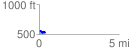
 0.370423 mi
 26.63 ft
 65.09 ft
 -38.46 ft
 3.33 %
GPX Downloads: Track Route
![]()
|
| at: |
Sumter National Forest - Long Cane District |
show on map
animate
0.370423 mi
26.63 ft
65.09 ft
-38.46 ft
3.33 %