|
| at: |
Sumter National Forest - Long Cane District |
Data from USFS GIS
 show on map
 animate
Trail users:


Elevation Profile
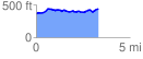
 3.336327 mi
 282.41 ft
 197.27 ft
 85.14 ft
 1.60 %
GPX Downloads: Track Route
![]()
|
| at: |
Sumter National Forest - Long Cane District |
show on map
animate
3.336327 mi
282.41 ft
197.27 ft
85.14 ft
1.60 %