| at: |
Sumter National Forest - Long Cane District |
Data from USFS GIS
 show on map
 animate
Trail users:


Elevation Profile
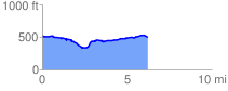
 6.351370 mi
 277.05 ft
 312.38 ft
 -35.34 ft
 0.93 %
GPX Downloads: Track Route
![]()
| at: |
Sumter National Forest - Long Cane District |
show on map
animate
6.351370 mi
277.05 ft
312.38 ft
-35.34 ft
0.93 %