|
| at: |
Sumter National Forest - Long Cane District |
Data from USFS GIS
 show on map
 animate
Trail users:


Elevation Profile
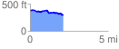
 2.121941 mi
 112.16 ft
 197.87 ft
 -85.71 ft
 1.77 %
GPX Downloads: Track Route
![]()
|
| at: |
Sumter National Forest - Long Cane District |
show on map
animate
2.121941 mi
112.16 ft
197.87 ft
-85.71 ft
1.77 %