|
| at: |
Sumter National Forest - Long Cane District |
Data from USFS GIS
 show on map
 animate
Trail users:


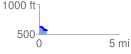
Elevation Profile
 0.480356 mi
 14.07 ft
 88.33 ft
 -74.26 ft
 3.48 %
GPX Downloads: Track Route
![]()
|
| at: |
Sumter National Forest - Long Cane District |
show on map
animate
0.480356 mi
14.07 ft
88.33 ft
-74.26 ft
3.48 %