| at: |
Sumter National Forest - Long Cane District |
Data from USFS GIS
 show on map
 animate
Trail users:


Elevation Profile
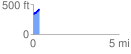
 0.354878 mi
 78.90 ft
 2.79 ft
 76.11 ft
 4.21 %
GPX Downloads: Track Route
![]()
| at: |
Sumter National Forest - Long Cane District |
show on map
animate
0.354878 mi
78.90 ft
2.79 ft
76.11 ft
4.21 %