| at: |
Sumter National Forest - Long Cane District |
Data from USFS GIS
 show on map
 animate
Trail users:

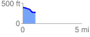
Elevation Profile
 1.085431 mi
 25.30 ft
 147.95 ft
 -122.65 ft
 2.58 %
GPX Downloads: Track Route
![]()
| at: |
Sumter National Forest - Long Cane District |
show on map
animate
1.085431 mi
25.30 ft
147.95 ft
-122.65 ft
2.58 %