|
| at: |
Sumter National Forest - Long Cane District |
Data from USFS GIS
 show on map
 animate
Trail users:


Elevation Profile
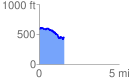
 1.565469 mi
 153.17 ft
 271.84 ft
 -118.67 ft
 3.29 %
GPX Downloads: Track Route
![]()
|
| at: |
Sumter National Forest - Long Cane District |
show on map
animate
1.565469 mi
153.17 ft
271.84 ft
-118.67 ft
3.29 %