| at: |
Sumter National Forest - Long Cane District |
Data from USFS GIS
 show on map
 animate
Trail users:


Elevation Profile
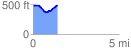
 1.401554 mi
 151.54 ft
 143.63 ft
 7.91 ft
 2.05 %
GPX Downloads: Track Route
![]()
| at: |
Sumter National Forest - Long Cane District |
show on map
animate
1.401554 mi
151.54 ft
143.63 ft
7.91 ft
2.05 %