|
| at: |
Sumter National Forest - Long Cane District Cedar Springs OHV Trail |
Data from USFS GIS
 show on map
 animate
Trail users:


Elevation Profile
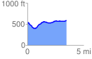
 3.526560 mi
 283.58 ft
 218.23 ft
 65.34 ft
 1.52 %
GPX Downloads: Track Route