|
| at: |
Sumter National Forest - Long Cane District |
Data from USFS GIS
 show on map
 animate
Trail users:


Elevation Profile
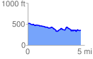
 4.705064 mi
 315.79 ft
 472.99 ft
 -157.20 ft
 1.90 %
GPX Downloads: Track Route
![]()
|
| at: |
Sumter National Forest - Long Cane District |
show on map
animate
4.705064 mi
315.79 ft
472.99 ft
-157.20 ft
1.90 %