| at: |
Sumter National Forest - Long Cane District |
Data from USFS GIS
 show on map
 animate
Trail users:


Elevation Profile
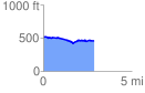
 2.882118 mi
 112.72 ft
 162.96 ft
 -50.24 ft
 1.07 %
GPX Downloads: Track Route
![]()
| at: |
Sumter National Forest - Long Cane District |
show on map
animate
2.882118 mi
112.72 ft
162.96 ft
-50.24 ft
1.07 %