| at: |
Berry College |
Data from David Muse
 show on map
 animate
South of where the Viking Trail crosses, this road is closed to bikes and pedestrians.
Trail users:


Elevation Profile
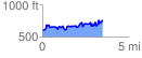
 3.468321 mi
 624.07 ft
 476.20 ft
 147.88 ft
 3.41 %
GPX Downloads: Track Route