| at: |
Harbison State Forest |
Data from David Muse
 show on map
 animate
Trail users:


Elevation Profile
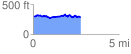
 2.769929 mi
 253.50 ft
 263.55 ft
 -10.05 ft
 1.80 %
GPX Downloads: Track Route
![]()
| at: |
Harbison State Forest |
show on map
animate
2.769929 mi
253.50 ft
263.55 ft
-10.05 ft
1.80 %