| at: |
Harbison State Forest |
Data from David Muse
 show on map
 animate
Trail users:


Elevation Profile
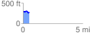
 0.533658 mi
 35.81 ft
 64.78 ft
 -28.97 ft
 2.30 %
GPX Downloads: Track Route
![]()
| at: |
Harbison State Forest |
show on map
animate
0.533658 mi
35.81 ft
64.78 ft
-28.97 ft
2.30 %