| at: |
Clemson Experimental Forest |
Data from Positive Flow
 show on map
 animate
Trail users:


Elevation Profile
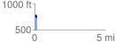
 0.166270 mi
 28.80 ft
 52.81 ft
 -24.01 ft
 6.02 %
GPX Downloads: Track Route
![]()
| at: |
Clemson Experimental Forest |
show on map
animate
0.166270 mi
28.80 ft
52.81 ft
-24.01 ft
6.02 %