| at: |
Clemson Experimental Forest |
Data from Positive Flow
 show on map
 animate
Trail users:


Elevation Profile
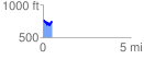
 0.501522 mi
 94.19 ft
 116.14 ft
 -21.95 ft
 4.39 %
GPX Downloads: Track Route
![]()
| at: |
Clemson Experimental Forest |
show on map
animate
0.501522 mi
94.19 ft
116.14 ft
-21.95 ft
4.39 %