| at: |
Clemson Experimental Forest |
Data from Positive Flow
 show on map
 animate
Trail users:


Elevation Profile
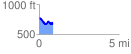
 0.864752 mi
 119.77 ft
 213.51 ft
 -93.74 ft
 4.68 %
GPX Downloads: Track Route
![]()
| at: |
Clemson Experimental Forest |
show on map
animate
0.864752 mi
119.77 ft
213.51 ft
-93.74 ft
4.68 %