| at: |
Clemson Experimental Forest |
Data from Positive Flow
 show on map
 animate
Trail users:


Elevation Profile
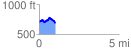
 1.016221 mi
 170.82 ft
 170.82 ft
 0.00 ft
 3.18 %
GPX Downloads: Track Route
![]()
| at: |
Clemson Experimental Forest |
show on map
animate
1.016221 mi
170.82 ft
170.82 ft
0.00 ft
3.18 %