| at: |
North Mills River Recreation Area |
Data from Karlos Bernart
 show on map
 animate
Trail users:


Elevation Profile
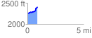
 0.889425 mi
 199.27 ft
 44.17 ft
 155.10 ft
 4.24 %
GPX Downloads: Track Route
![]()
| at: |
North Mills River Recreation Area |
show on map
animate
0.889425 mi
199.27 ft
44.17 ft
155.10 ft
4.24 %