| at: |
Big Cedar Wilderness Trails |
Data from David Muse
 show on map
 animate
Trail users:


Elevation Profile
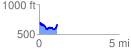
 1.147963 mi
 205.64 ft
 229.87 ft
 -24.23 ft
 3.79 %
GPX Downloads: Track Route
![]()
| at: |
Big Cedar Wilderness Trails |
show on map
animate
1.147963 mi
205.64 ft
229.87 ft
-24.23 ft
3.79 %