| at: |
Bent Creek |
Data from David Muse
 show on map
 animate
Trail users:


Elevation Profile
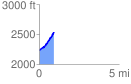
 0.937559 mi
 310.89 ft
 6.96 ft
 303.93 ft
 6.28 %
GPX Downloads: Track Route
![]()
| at: |
Bent Creek |
show on map
animate
0.937559 mi
310.89 ft
6.96 ft
303.93 ft
6.28 %