| at: |
Bent Creek |
Data from David Muse
 show on map
 animate
Trail users:


Elevation Profile
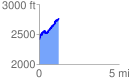
 1.236224 mi
 497.13 ft
 134.48 ft
 362.66 ft
 7.62 %
GPX Downloads: Track Route
![]()
| at: |
Bent Creek |
show on map
animate
1.236224 mi
497.13 ft
134.48 ft
362.66 ft
7.62 %