| at: |
Bent Creek |
Data from Dave Greenwell
 show on map
 animate
Trail users:


Elevation Profile
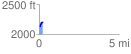
 0.218941 mi
 84.53 ft
 1.42 ft
 83.11 ft
 7.31 %
GPX Downloads: Track Route
![]()
| at: |
Bent Creek |
show on map
animate
0.218941 mi
84.53 ft
1.42 ft
83.11 ft
7.31 %