| at: |
Bent Creek |
Data from David Muse
 show on map
 animate
Trail users:


Elevation Profile
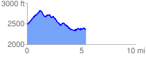
 5.439021 mi
 1028.77 ft
 1153.38 ft
 -124.61 ft
 4.02 %
GPX Downloads: Track Route
![]()
| at: |
Bent Creek |
show on map
animate
5.439021 mi
1028.77 ft
1153.38 ft
-124.61 ft
4.02 %